Best ATV Trails in New Mexico (2026)

Alana Azzouz is a Senior Editor at Searchshop Media Network with over a decade of experience in consumer content quality and editorial standards. She has reviewed thousands of product guides, buying articles, and comp…
Why trust us
BestATVTrails trail guides are researched by riders with decades of powersports experience. Our lead researcher spent 30+ years in powersports retail and has ridden trails across a dozen US states. Every gear recommendation is sourced from real product research matched to specific terrain — not paid placements or generic affiliate lists.

Best ATV Trails in New Mexico
Gear for This Trail

Because New Mexico combines dust, rock, elevation swings, and long distances between services, we recommend a gear setup that balances protection, navigation, and self-sufficiency.
| Gear Type | Brand | Product | Why It Suits New Mexico Trails | Approx. Price |
|---|---|---|---|---|
| Helmet | Bell | Qualifier DLX MIPS Helmet | Good ventilation for hot desert rides, full-face protection for dusty and rocky terrain, and MIPS adds impact management for faster forest-road travel. | $230-$300 |
| Gloves / Protective Gear | Alpinestars | SMX-2 Air Carbon V2 Gloves | Lightweight and breathable for high-desert heat, with knuckle protection that helps on brushy, rocky trails around Cedro and Red River. | $70-$100 |
| Chest / Upper Body Protection | Alpinestars | Bionic Action V2 Protection Jacket | A smart choice for riders tackling rougher mountain routes or ledgy canyon terrain where roost, branches, and tip-overs are realistic. | $180-$250 |
| Terrain-Specific Recovery Item | Rhino USA | Recovery Tow Strap (3" x 20') | Useful in sandy washes at Glade Run, muddy monsoon ruts in Cloudcroft, or when helping another ATV on a steep loose climb. Compact and easy to carry. | $35-$50 |
| Navigation Item | Garmin | Tread Powersport Navigator | New Mexico's trail systems often involve junction-heavy forest roads and broad desert networks; dedicated powersports GPS is a major advantage where cell service is weak. | $500-$700 |
| Comfort / Utility Item | CamelBak | M.U.L.E. Hydration Pack | Essential for desert heat and long mountain loops. Hands-free water access matters when temperatures are high and services are far apart. | $100-$140 |
If your machine sees frequent rock contact, we also recommend looking into a model-specific Ricochet Off-Road aluminum skid plate set. Pricing varies widely by ATV model, but it is one of the best upgrades for New Mexico's rocky mountain systems.
Introduction
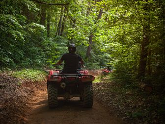
The best ATV trails in New Mexico span an impressive range of landscapes, from dry high-desert mesas and red-rock canyon country to cool alpine forest above 9,000 feet. That variety is exactly why riders travel here: few states let us cover sandy arroyos in the morning, climb rocky mountain roads by lunch, and finish the day in pine forest with long views across the Sangre de Cristo or Sacramento ranges. New Mexico also has a strong mix of designated OHV trail systems, national forest routes, and BLM-accessible terrain, so both casual riders and experienced off-roaders can find something that fits.
For this guide, we focused on some of the state's most talked-about riding areas: Red River / Questa in the Carson National Forest, Cloudcroft and the Sacramento Ranger District, the Glade Run Recreation Area near Farmington, and the Cedro Peak / East Mountain area near Albuquerque. Together, they represent the terrain New Mexico is known for—dusty desert, loose rock, steep grades, forest roads, and weather that can swing from triple-digit heat at low elevation to near-freezing mornings in the mountains.
Trail Overview

New Mexico does not have one single mega-system that defines the state; instead, the best riding comes from several regional trail networks. Here are the key systems we recommend researching first:
1. Red River / Questa / Goose Lake Area
- Region: Carson National Forest, northern New Mexico
- Approximate trail mileage: 100+ miles of connected roads and OHV-friendly routes in the broader area
- Difficulty: Green to Black
- Elevation: Roughly 8,700 to over 11,000 feet
- Best season: Late June through early October
- Nearest towns: Red River, Questa, Eagle Nest
- Permit notes: New Mexico OHV registration or valid out-of-state permit/registration generally required; check Carson National Forest MVUM and local seasonal rules
2. Cloudcroft / Sacramento Ranger District
- Region: Lincoln National Forest, southern New Mexico
- Approximate trail mileage: 100+ miles when combining open forest roads and motorized routes in the district
- Difficulty: Green to Blue, with some Black segments on rougher connectors
- Elevation: About 8,500 to 9,500+ feet
- Best season: May through October, depending on snow and monsoon moisture
- Nearest town: Cloudcroft
- Permit notes: New Mexico OHV compliance required; verify route legality in Lincoln National Forest before riding
3. Glade Run Recreation Area
- Region: BLM land north of Farmington
- Approximate trail mileage: 200+ miles of roads, washes, and play-area style routes across the broader recreation area
- Difficulty: Green to Black
- Elevation: Around 5,400 to 6,500 feet
- Best season: March to May and September to November
- Nearest town: Farmington
- Permit notes: New Mexico OHV registration/permit rules apply; BLM access is generally open but temporary closures can happen
4. Cedro Peak / East Mountain Trails
- Region: Cibola National Forest east of Albuquerque
- Approximate trail mileage: Smaller network, but enough for a full day of linked riding and exploration
- Difficulty: Blue to Black
- Elevation: Roughly 7,000 to 8,500 feet
- Best season: Spring and fall, with summer monsoon caution
- Nearest towns: Tijeras, Cedar Crest, Albuquerque
- Permit notes: Confirm current motorized access and staging rules with Cibola National Forest
Trail Conditions & Terrain
New Mexico riding is defined by contrast. We recommend planning for terrain that changes quickly, sometimes within the same loop.
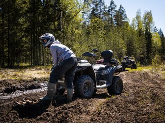
In the northern mountain systems around Red River and Questa, riders can expect decomposed granite, embedded rock, shelfy climbs, water bars, rutted forest roads, and occasional mud pockets after rain. Routes toward old mining areas and high basins often start on wider dirt roads, then tighten into rougher two-track with loose baby-head rock and off-camber turns. At altitude, traction can change fast when shaded sections hold moisture or snowmelt. Creek crossings are usually minor and seasonal, but runoff can cut channels into the trail.
In Cloudcroft and the Sacramento Mountains, the terrain is generally more forested and cooler, with hardpack dirt, roots, loose rock, and some sandy stretches in lower sections. Grades are often moderate, but washouts and erosion can make an easy road unexpectedly technical. Monsoon season can leave puddles, slick clay, and downed branches. The big challenge here is not usually sheer exposure but how quickly a smooth forest road can turn rocky and choppy.
The Glade Run Recreation Area is classic high-desert riding. Expect dry washes, sandy pockets, ledgy climbs, hard-baked dirt, loose gravel, and short steep hills cut into badlands-style terrain. Visibility can be excellent, but dust can hang in the air on busy weekends. This is one of the better places in the state for riders who enjoy open sightlines and a more exploratory feel. Summer heat is serious here, and the surface can go from firm to powdery without much warning.
Around Cedro Peak, riders often encounter tighter, more technical terrain than they expect this close to Albuquerque. Trails and roads can include jagged rock, erosion ruts, narrow tree-lined sections, and steeper grades than the map suggests. It is a good zone for intermediate riders who want a challenge without committing to a full alpine ride. After storms, some sections become slick and deeply rutted.
Across all of these systems, the main recurring obstacles are:
- Loose rock and embedded stone
- Dust and reduced visibility
- Washouts and erosion channels
- Steep grades on mountain routes
- Heat at low elevation and cold wind at high elevation
- Sudden weather changes, especially during monsoon season
Difficulty & Who It's For
We use the Green / Blue / Black / Double-Black scale to help riders match expectations to conditions.
Green
Green-rated riding in New Mexico usually means wider graded forest roads, smoother desert two-track, and easier connector routes without major ledges or sustained steep climbs. These sections suit:
- Beginners on utility ATVs
- Families riding conservatively
- Riders new to mountain elevation or desert navigation
Examples include easier roads around Cloudcroft and selected open routes in the Glade Run area.
Blue
Blue is the sweet spot for many riders in New Mexico. Expect moderate rock, occasional ruts, loose climbs, uneven surfaces, and route-finding that requires attention. These trails suit:
- Riders with a few trips under their belt
- Sport ATV riders looking for variety
- Utility ATV riders comfortable with rougher terrain
Much of Cedro Peak and many routes around Red River fit this level.
Black
Black-rated routes bring steeper grades, chunk rock, deeper erosion, tighter turns, and more commitment. Recovery may be difficult if you break down far from town. These suit:
- Experienced riders
- Groups carrying tools, water, and navigation backup
- Machines with good tires, clearance, and skid protection
Higher mountain routes near Goose Lake, rough connectors in Cedro, and more technical desert hill sections in Glade Run can fall into this category.
Double-Black
New Mexico does not always label routes with ski-style ratings, but some user-created or poorly maintained lines effectively ride like double-black terrain when conditions deteriorate. Think severe rock gardens, exposure, major washouts, or highly technical hillclimbs. We do not recommend these for casual ATV travelers or loaded family rides. These are best left to very experienced local riders who know the route and current conditions.
Permits & Access
New Mexico has statewide OHV rules that riders need to take seriously before unloading.
OHV registration and sticker requirements
In general, ATVs operated on public land in New Mexico need to comply with the state's OHV registration or permit system. If you are a resident, that usually means current New Mexico OHV registration. If you are visiting from another state, reciprocity may apply if your machine is legally registered in your home state, but we recommend confirming current requirements with the New Mexico Department of Game and Fish OHV Program before your trip.
Spark arrestor and equipment rules
For national forest riding, we recommend confirming that your ATV meets USFS spark arrestor requirements where applicable. Basic safety equipment and age-related rules may also apply.
Parking and staging
- Red River / Questa: Riders commonly stage from local trailheads, forest access points, or OHV-friendly lodging areas where allowed. Parking fills quickly on summer weekends.
- Cloudcroft: Use designated forest access points and legal roadside staging areas only; do not block gates or private drives.
- Glade Run: This area is relatively friendly for dispersed staging, but riders should still use durable surfaces and respect signed closures.
- Cedro Peak: Staging is more limited, so arrive early and verify current parking guidance with Cibola National Forest.
Permit costs and reservations
Most of these trail systems do not require a day-use reservation like a major OHV park, but costs can still arise through registration, camping fees, or local trailhead use fees. In most cases:
- No advance trail reservation is required for basic day riding
- Camping fees may apply at developed campgrounds
- OHV registration/permit costs depend on residency and current state rules
Because rules can change, we recommend checking:
- New Mexico Department of Game and Fish OHV Program
- Carson National Forest
- Lincoln National Forest
- Cibola National Forest
- BLM Farmington Field Office for Glade Run updates
Tips for Riding This System
Start earlier than you think you need to. In lower-elevation desert areas like Glade Run, heat builds fast. In mountain zones, afternoon storms are common. Early starts give us the best window.
Do not judge a route only by mileage. A 20-mile loop near Red River or Cedro can take much longer than expected if it includes rock gardens, steep climbs, or washouts.
Carry more water than usual. New Mexico's dry air can hide dehydration, especially when we move between cool morning mountain air and warm lower elevations later in the day.
Download maps before leaving town. Cell coverage is inconsistent in all four regions. A GPS or offline map app is far more than a convenience here.
Watch the weather during monsoon season. Even if the sky above you looks clear, upstream rain can affect arroyos, low crossings, and erosion-prone desert routes.
Respect seasonal closures and private land boundaries. Some of the best riding areas have a patchwork of federal, state, and private land nearby. Stay on legal motorized routes.
Plan fuel around the nearest town. Red River, Questa, Cloudcroft, Farmington, and Tijeras all make logical supply stops, but once we are on the trail, fuel access can be limited or nonexistent.
FAQ
What is the best time of year to ride ATV trails in New Mexico?
For desert areas like Glade Run, spring and fall are best because summer heat can be extreme. For mountain systems like Red River and Cloudcroft, late spring through early fall is ideal, though snow can linger at higher elevations.
Do I need a permit to ride an ATV in New Mexico?
Usually, yes—at minimum you need to meet New Mexico OHV registration or out-of-state reciprocity requirements. Specific trail systems may also have local access, camping, or seasonal rules.
Are New Mexico ATV trails beginner-friendly?
Yes, some are. Cloudcroft and selected routes in Glade Run offer easier Green and Blue terrain. However, many New Mexico routes become technical quickly, so beginners should stick to mapped easy roads and avoid high-altitude rockier routes until comfortable.
Which New Mexico ATV area is best for scenic mountain riding?
The Red River / Questa area stands out for scenic alpine riding, mining history, and high-elevation views. If you want cooler summer temperatures and forested terrain, it is one of the strongest choices in the state.
Get our best guides in your inbox
Final Thoughts
If we had to summarize the best ATV trails in New Mexico in one phrase, it would be variety with consequences. The state offers exceptional terrain diversity, but it also demands preparation. A route that looks mellow on the map may involve altitude, loose rock, summer lightning, or long distances from help. That is part of the appeal for experienced riders—and part of why gear, hydration, navigation, and permit research matter here more than in many easier trail states.

For riders who want open desert exploration, Glade Run is hard to ignore. For cool forest mileage, Cloudcroft is a reliable favorite. For technical challenge and mountain scenery, Red River and Questa deserve a spot near the top of any New Mexico list. And for a quick but still demanding ride close to the city, Cedro Peak remains a strong option.
Wherever you go, ride legal routes, prepare for weather swings, and build your setup around dust, rock, and self-reliance.
Top Picks & Comparison
| # | Product | Price | Rating | ||
|---|---|---|---|---|---|
| #1 | |
NM Backcountry Discovery Route |
For $3.99 to rent | — | Check Price on Amazon → |
| #2 |  |
Off-Road Nirvana: Finding the Top 100+ Trails in the Rocky Mountains: An Ultimate Bucket List of 4X4 Trails in Arizona, Colorado, Idaho, Montana, Nevada, New Mexico, Utah, and Wyoming. |
$19.99 | (84) | Check Price on Amazon → |
| #3 | ![Paiute ATV Trail Map [Fish Lake National Forest, BLM] (National Geographic Trails Illustrated Map, 708)](https://m.media-amazon.com/images/I/91RO-SWSqmL._AC_UY218_.jpg) |
Paiute ATV Trail Map [Fish Lake National Forest, BLM] (National Geographic Trails Illustrated Map, 708) |
$14.95 | (211) | Check Price on Amazon → |
| #4 |  |
Best Dirt Roads in New Mexico - New Mexico Adventure Series Map |
$21.95 | (2) | Check Price on Amazon → |