Gunnison National Forest ATV Trails Guide

Ellen Kietzmann brings more than 25 years of senior leadership in the RV and outdoor recreation industry. She spent 22 years at Blue Ox — rising from Vice President of Sales & HR to President — where she grew the deal…
Why trust us
BestATVTrails trail guides are researched by riders with decades of powersports experience. Our lead researcher spent 30+ years in powersports retail and has ridden trails across a dozen US states. Every gear recommendation is sourced from real product research matched to specific terrain — not paid placements or generic affiliate lists.

Gunnison National Forest ATV Trails Guide
Gear for This Trail

High elevation, jagged rock, shifting weather, and remote mountain travel make gear selection especially important here. We recommend prioritizing impact protection, navigation, and recovery readiness.
| Gear Type | Brand | Product | Why It Suits Gunnison National Forest | Approx. Price |
|---|---|---|---|---|
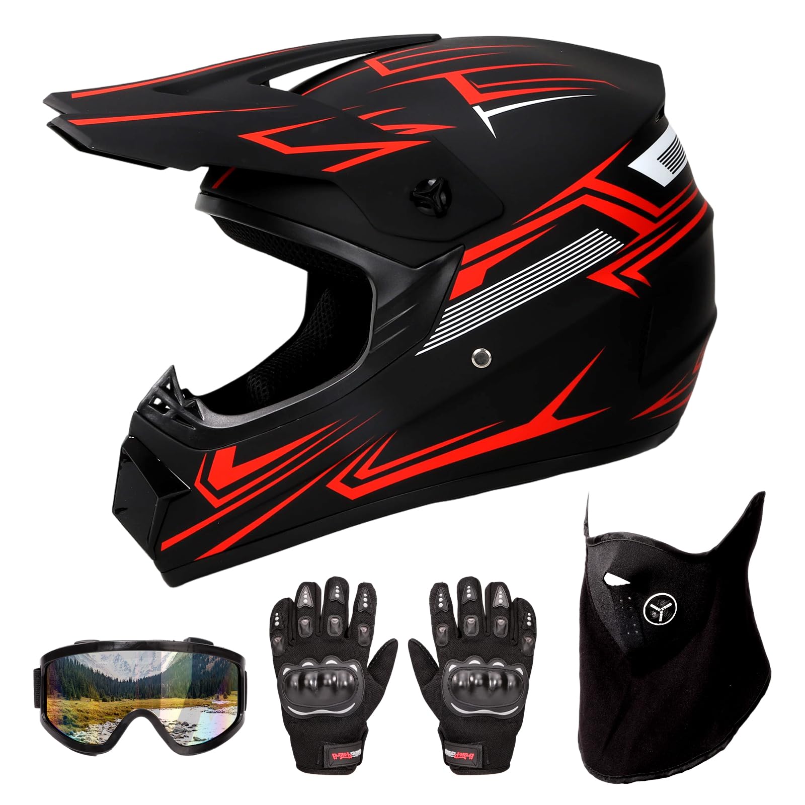 Helmet Helmet |
Bell | Qualifier Full-Face Helmet | A full-face design helps on dusty forest roads, cold high-elevation mornings, and rocky sections where roost and branches are common. It’s a practical choice for riders mixing speed on roads with technical mountain climbs. | $120-$180 |
| Protective Gear | Alpinestars | Bionic Action Chest Protector | Gunnison’s rocky passes and off-camber climbs make upper-body protection a smart upgrade. This protector adds chest and back coverage without being overly bulky for long days in changing temperatures. | $130-$180 |
| Gloves | Fox Racing | Dirtpaw Gloves | These are a solid match for long mountain rides where we need grip on rough bars, light knuckle protection, and enough dexterity for controls, GPS use, and trail-side adjustments. | $25-$40 |
| Terrain-Specific Item | Garmin | Tread Powersport GPS | Cell service can be unreliable across Taylor Park, Tincup, and remote forest roads. A dedicated powersports GPS helps with route tracking, navigation, and staying oriented across a large, interconnected trail system. | $500-$700 |
| Recovery Item | Rhino USA | Recovery Tow Strap | Rocky climbs, mud pockets, and creek approaches make recovery gear worth carrying. A quality tow strap is one of the simplest ways to handle a stuck ATV without overpacking. | $30-$45 |
| Comfort / Utility Item | ARB | Portable Air Compressor | Tire pressure matters on Gunnison’s mix of sharp rock, loose dirt, and longer road connectors. A portable compressor lets us air down for traction and reinflate before pavement or faster forest-road travel. | $300-$380 |
If your machine sees frequent rock contact in Colorado, we also suggest looking into model-specific skid plates from brands like Ricochet Off-Road or Factory UTV, even though fitment depends on your ATV model.
Introduction
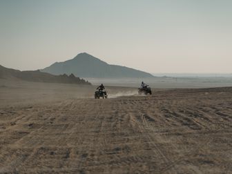
Gunnison National Forest ATV trails draw riders for one big reason: variety. In a single trip, we can move from dusty forest roads and shaded pine stands to alpine meadows, shelfy mountain routes, and rocky high-country passes with sweeping views of the Elk and Sawatch ranges. The broader Gunnison-area trail network, including popular OHV zones near Taylor Park, Tincup, Pitkin, Crested Butte, and Lake City, gives ATV and side-by-side riders access to some of Colorado’s most memorable backcountry terrain.
What makes this area special is the combination of scenery and challenge. We’re not just talking about casual cruising. Many routes climb above 10,000 feet, where weather changes quickly, traction varies by the hour, and loose rock can turn a simple climb into a technical line choice. Riders also come here for the sense of adventure: old mining roads, creek crossings, wildflower-filled meadows, and long connector routes that let us build full-day loops. Add in the realities of bear country, afternoon storms, and seasonal trail closures, and Gunnison becomes a destination that rewards preparation. For riders who want true mountain ATV travel in Colorado, this forest system is one of the best places to start.
Trail Overview

Gunnison National Forest is a large forest with multiple motorized trail zones rather than one single ATV park, so mileage depends on the district and connected routes you choose. The most popular ATV riding areas are centered around Taylor Park, Tincup, Pitkin, Lake City, and motorized roads/trails on the Gunnison Ranger District and nearby public lands.
Key stats
- Estimated rideable motorized mileage: 300+ miles across the broader Gunnison-area OHV network, depending on district, seasonal openings, and route classification
- Difficulty range: Green to Double-Black, from graded forest roads to steep, rocky mountain passes
- Elevation: Roughly 7,500 to over 12,500 feet, with many popular routes above 10,000 feet
- Permit requirements: Colorado OHV registration or permit generally required for off-highway vehicles using designated OHV routes
- Best season: Late June through early October, with peak access usually July through September depending on snowpack
- Nearest towns: Gunnison, Almont, Crested Butte, Pitkin, Tincup, and Lake City depending on where you stage
Popular ATV-accessible route areas
Some of the best-known motorized routes in and around the forest include:
- Cumberland Pass
- Tincup Pass
- Italian Creek / American Flag Mountain area
- Taylor Park trail network
- Pitkin area routes
- Lake City-side Alpine Loop connectors such as Cinnamon Pass and Engineer Pass on roads open to licensed/high-clearance vehicles and route-appropriate OHVs where allowed
Always verify the current Motor Vehicle Use Map (MVUM) and district rules before riding, because route designations can change.
Trail Conditions & Terrain
The terrain across Gunnison National Forest is classic Colorado high-country riding: beautiful, varied, and often more technical than it first appears.
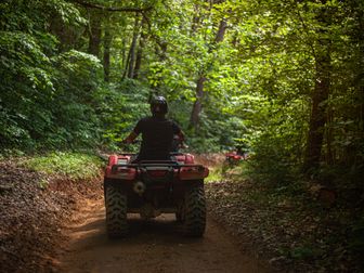
At lower elevations, we typically find hard-packed dirt forest roads, embedded rock, loose gravel corners, and washboard sections. These roads can feel easy early in the day, but summer traffic, rain runoff, and braking bumps can rough them up fast. As we climb higher, the surface often changes to chunky rock, ledgey climbs, talus-like rubble, and narrow shelf roads with limited room to pass.
Routes around Taylor Park and Tincup are especially known for their mix of rock gardens, steep switchbacks, shallow to moderate creek crossings, and loose decomposed granite. On passes like Tincup Pass, riders can expect sustained rock, off-camber sections, and traffic from Jeeps, dirt bikes, and side-by-sides. Cumberland Pass is generally more approachable but still features altitude, weather exposure, and rocky stretches that demand attention.
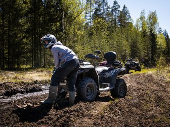
In meadow and basin areas, the riding can open up into smoother two-track and old mining roads, but these sections should not be confused with easy lowland trails. Mud holes can develop after storms, and snowmelt can leave ruts and standing water well into summer. Afternoon rain can turn otherwise manageable climbs slick, especially where the trail mixes dirt over rock.
Creek crossings vary by route and time of year. Early summer runoff can make crossings deeper and faster than expected, while late-season crossings are usually more predictable. We also researched frequent reports of embedded rock steps, erosion channels, and tight line choices on more advanced trails. Tire placement matters here.
Another major factor is elevation. Power loss affects naturally aspirated machines, and riders often feel fatigue sooner above 10,000 feet. Weather is equally important. Bluebird mornings can become hail, lightning, or cold rain by early afternoon. Even in mid-summer, temperatures can swing dramatically from valley staging areas to exposed passes.
Finally, this is bear country. If we camp or pack food, trash, or scented items, we need to secure them properly. Remote conditions also mean self-sufficiency matters more than on a small local trail system.
Difficulty & Who It's For
Because Gunnison National Forest includes everything from scenic roads to serious mountain routes, we recommend thinking about difficulty by individual trail rather than by the forest as a whole.
Green: Easy
Who it suits: Beginners, families, newer ATV riders, and anyone wanting scenic exploration over technical challenge.
These routes are typically wider forest roads or smoother two-track with moderate grades and fewer obstacles. Some lower-elevation connectors and easier roads near staging areas fall into this category. Riders still need to manage dust, washboard, altitude, and changing weather, but the line choices are straightforward.
Blue: Moderate
Who it suits: Riders with some off-road experience who are comfortable climbing, descending, and handling loose rock.
Many of Gunnison’s most enjoyable routes land here. Expect rocky patches, steeper grades, occasional creek crossings, and tighter turns. Cumberland Pass often feels like a Blue ride for prepared riders in good conditions, though weather can bump it up.
Black: Difficult
Who it suits: Experienced mountain riders with strong throttle control, good braking habits, and confidence on rough terrain.
Black-rated routes often include sustained rock, shelf exposure, larger embedded obstacles, and technical climbs or descents. Tincup Pass and portions of the Taylor Park network can ride like Black routes, especially when traffic, rain, or erosion worsen conditions.
Double-Black: Extreme / Expert Only
Who it suits: Highly experienced riders on appropriately equipped machines who understand Colorado high-country risk.
This rating applies to the roughest, steepest, and most technical segments in the broader area, especially side routes with serious rock, narrow lines, and consequences for mistakes. Conditions can elevate difficulty quickly. A route that feels Black in dry weather can edge toward Double-Black after storms or during early season runoff.
Permits & Access
Access rules in Gunnison National Forest depend on the exact ranger district, route designation, and whether your machine is street legal or registered as an OHV.
OHV registration and sticker requirements
For most ATVs and off-highway vehicles in Colorado, we researched that riders need either:
- a valid Colorado OHV registration, or
- a Colorado OHV permit for out-of-state vehicles
These are managed by Colorado Parks and Wildlife (CPW). Fees can change, but riders should expect an annual cost generally in the low-$30 range. Check CPW directly before your trip for current pricing and purchase options.
Route legality
Not every road or pass is open to every machine type. Some routes are open only to:
- licensed highway vehicles,
- certain width classes,
- motorcycles only, or
- designated OHVs.
We strongly recommend checking the Motor Vehicle Use Map (MVUM) for the relevant district and confirming local restrictions with the Gunnison Ranger District or neighboring district office if your route crosses boundaries.
Parking and staging
Popular staging and trailer parking areas are commonly found near:
- Taylor Park Reservoir / Taylor Park trading area
- Tincup area access points
- Pitkin staging zones
- Lake City-side trailheads and public access lots
Parking availability varies widely. In peak summer, popular lots fill early, especially on weekends and holiday periods. Some campgrounds and trailheads have space for truck-and-trailer rigs, but not all do.
Reservation requirements
There is generally no trail reservation system for riding the forest roads and OHV routes themselves. However:
- campgrounds may require reservations, especially developed sites
- some staging-adjacent campgrounds book far ahead in summer
- dispersed camping rules may change by district
Fees and passes
Most trail riding itself does not require a separate per-trail permit beyond OHV compliance, but developed recreation sites, campgrounds, or certain day-use areas may charge fees. Always review current Forest Service and CPW information before your trip.
Tips for Riding This System
Start early for weather and traffic. In Gunnison, morning rides are usually calmer and drier. By afternoon, lightning, hail, and heavy trail traffic can make exposed passes much less enjoyable.
Plan for altitude, not just mileage. A 40-mile day at 11,000 feet can feel bigger than a much longer ride at lower elevation. We recommend carrying more water than usual and pacing technical climbs.
Use the MVUM and a dedicated GPS together. Trail intersections, county roads, and pass connectors can get confusing. Paper maps help, but a mounted GPS is even better when weather rolls in.
Expect mixed-use traffic around blind corners. Jeeps, rental side-by-sides, adventure bikes, and full-size trucks may all appear on the same route. Stay right, control speed, and avoid cutting switchbacks.
Carry basic recovery and repair gear. At minimum, bring a tow strap, tire repair supplies, tools, and a way to air tires back up. Sharp rock and remote mileage make small problems harder to ignore.
Respect wildlife and camp clean in bear country. Store food, trash, and scented items securely. Don’t leave coolers or garbage accessible at camp or in open truck beds overnight.
Check snowpack and seasonal openings before you drive out. High passes can open late in heavy snow years, and a route that appears open on a map may still be blocked by drifts, runoff, or storm damage.
FAQ
Are Gunnison National Forest ATV trails beginner friendly?
Some are. Easier forest roads and lower-difficulty connectors can work well for beginners, but many of the area’s famous routes are rocky, steep, and high elevation. New riders should stick to Green and easier Blue routes and avoid technical passes until they gain experience.
Do I need a Colorado OHV sticker for Gunnison National Forest?
In most cases, yes. ATVs using designated OHV routes generally need a valid Colorado OHV registration or out-of-state OHV permit. Street-legal status alone does not automatically replace all OHV compliance requirements for every machine and route, so verify your specific setup.
What are the best months to ride Gunnison National Forest?
July through September is usually the sweet spot. Late June can be good in lighter snow years, while October can bring cold temperatures and early snow. High passes often depend heavily on annual snowpack.
Is Tincup Pass suitable for ATVs?
It can be, but it is not a casual ride. Tincup Pass is one of the area’s better-known high-country routes and often includes loose rock, rough climbs, traffic, and exposure. It is best for experienced riders on well-maintained machines.
Gunnison National Forest rewards riders who come prepared. With the right route choice, current map checks, solid mountain gear, and realistic expectations about altitude and weather, this region offers some of the most memorable ATV riding in Colorado. For riders building a trip around scenery, challenge, and classic Rocky Mountain backcountry, it remains one of the strongest destinations we can recommend at BestATVTrails.
Get our best guides in your inbox
Top Picks & Comparison
| # | Product | Price | Rating | ||
|---|---|---|---|---|---|
| #1 | |
Motocross Helmet, DOT Approved Dirt Bike Helmet for Off-Road Riding Trail Riding Endurance Racing |
$65.99 | (6) | Check Price on Amazon → |