Pocahontas County ATV Trails Guide

Salem Hassan founded Travelcamp RV and brings 30+ years of hands-on RV, marine, and powersports retail experience to every review.
Why trust us
BestATVTrails trail guides are researched by riders with decades of powersports experience. Our lead researcher spent 30+ years in powersports retail and has ridden trails across a dozen US states. Every gear recommendation is sourced from real product research matched to specific terrain — not paid placements or generic affiliate lists.

Pocahontas County ATV Trails Guide
Gear for This Trail

Because Pocahontas County combines cool temperatures, remote forest riding, changing weather, and rocky mountain roads, we recommend gear that balances protection, navigation, and self-reliance.
| Gear Type | Brand | Product | Why it suits this trail | Approx. price |
|---|---|---|---|---|
| Helmet | Bell | Bell Qualifier Full-Face Helmet | A full-face helmet makes sense for dusty gravel roads, overhanging brush, and cool mountain air. The Bell Qualifier is a widely available option with good ventilation and a face shield that helps on long route-style rides. | $120-$180 |
| Gloves | Fox Racing | Fox Racing Dirtpaw Gloves | These work well for Pocahontas County because they give better grip on wet controls, light knuckle protection for brushy sections, and enough dexterity for all-day forest riding. | $25-$40 |
| Protective gear | Alpinestars | Alpinestars Bionic Action Chest Protector | On rocky, remote mountain routes, upper-body protection is a smart upgrade. This model adds chest and back coverage without feeling overly bulky for trail and utility ATV use. | $130-$180 |
| Terrain-specific item | Garmin | Garmin Tread Powersport GPS | This is one of the best fits for Pocahontas County because cell service can be unreliable. A dedicated powersports GPS helps with route tracking, navigation, and backtracking in remote forest sections. | $500-$700 |
| Recovery item | Rhino USA | Rhino USA Recovery Tow Strap | Even if you stay on easier routes, mud pockets, washouts, and slick grades make a recovery strap worth carrying. This is especially important when riding with a group in isolated areas. | $30-$45 |
| Comfort/utility item | Kolpin | Kolpin Rhino Grip XLR Double Mount | Mountain riding often means carrying extra tools, a saw, shovel, or fishing rod. These mounts are useful for securing gear to your ATV rack when you're riding long, mixed-condition routes. | $35-$50 |
If your machine does not already have strong underbody protection, we also suggest looking into a model-specific skid plate kit from brands like Ricochet Off-Road Armor or Rival. Rocky drainage cuts and embedded stone can punish factory protection on mountain routes.
Introduction
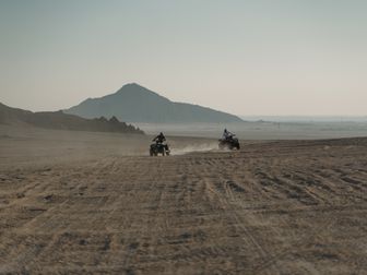
If you're researching Pocahontas County WV ATV trails, you're probably looking for a different kind of West Virginia ride: less crowded, more remote, and packed with mountain scenery. Pocahontas County sits in the heart of the high-elevation Allegheny region, and that means cooler temperatures, dense forest, long gravel forest roads, and a true backcountry feel that stands apart from more developed OHV systems elsewhere in the state.
We researched the riding opportunities riders most often use in and around Monongahela National Forest, including legal forest roads, connector routes near communities, and access points riders use as a base for exploring the county's mountainous terrain. This is not a single, heavily signed ATV park with one permit gate and one trailhead. Instead, Pocahontas County is best for riders who enjoy scenic route-style exploration, changing elevations, and a more self-sufficient day on the machine. Riders visit for the solitude, the cool summer weather, and the chance to combine ATV travel with camping, fishing, and mountain-town stops in places like Marlinton, Durbin, and Slatyfork.
Trail Overview

Pocahontas County riding is best understood as a network of legal riding opportunities rather than one unified branded trail system. Conditions and access can change, especially on public land, so we recommend confirming current rules with the Monongahela National Forest office and local county tourism sources before your trip.
Key stats
- Area: Pocahontas County, West Virginia
- Primary riding context: Monongahela National Forest region, forest roads, mountain access routes, remote backcountry travel
- Estimated rideable mileage: Roughly 60-150+ miles of route planning potential depending on current legal access, local connectors, and road openings
- Difficulty range: Green to Black
- Elevation: Commonly around 2,000 to over 4,000 feet depending on route
- Permit requirements: No single countywide ATV trail permit system; requirements vary by road, public land rules, and whether a route is open to street-legal vehicles only
- Best season: Late spring through fall; summer is especially attractive because of cooler mountain temperatures
- Nearest towns: Marlinton, Durbin, Green Bank, Slatyfork, Hillsboro
- Fuel/food hubs: Marlinton and Durbin are the most practical bases for supplies
Because this is a mountainous national forest region, route planning matters more here than at a dedicated trail park. Some roads are suitable only for licensed, street-legal machines, while others may be subject to seasonal closures, storm damage, or maintenance restrictions.
Trail Conditions & Terrain
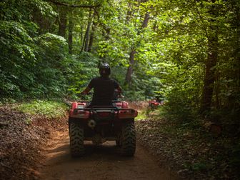
The defining feature of Pocahontas County riding is variety within a forested mountain environment. Expect long stretches of gravel and hard-packed forest road, mixed with loose stone, washboard sections, embedded rock, shallow ruts, and occasional muddy pockets after rain. In lower-traffic areas, the surface can narrow visually because of brush, overhanging limbs, and leaf cover, even when the route itself is technically a road.
Grades are one of the biggest factors here. This county sits in high mountain country, so riders should expect steady climbs, downhill braking sections, switchback-style turns, and off-camber edges on some routes. Even easier roads can feel more demanding when they stay steep for long periods. On shaded slopes, moisture lingers, which means a road that looks tame on the map may have slick clay, wet roots near pull-offs, or loose rock pushed into the travel line.
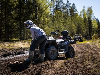
Water is another variable. You may encounter drainage crossings, wet runoffs, puddled depressions, and small creek-edge approaches depending on your route and the recent weather. These are usually not the deep, purpose-built mud obstacles found in private off-road parks, but they can still challenge traction and line choice. Heavy summer storms can also create fresh washouts or exposed rock shelves.
Remote terrain is part of the appeal, but it changes the riding experience. Cell coverage can be inconsistent, and some segments feel isolated even during peak season. Fallen limbs, fog, and rapidly changing mountain weather are all realistic possibilities. In cooler months, morning frost and wet leaves can make even moderate grades surprisingly slick.
Scenery is a major payoff. Riders can expect dense hardwood forest, spruce-influenced high-country sections, ridgeline views in select areas, and access to the broader outdoor atmosphere that makes the Monongahela National Forest region so popular with campers, anglers, and overland travelers.
Difficulty & Who It's For
We rate the broader Pocahontas County riding experience as Green to Black, depending on weather, route selection, and whether you're sticking to maintained gravel roads or venturing onto rougher mountain connectors where legal access exists.
Green
Who it's for: Beginners with basic machine control, families on easier route segments, and riders who want scenic exploration over technical challenge.
Green-level riding here usually means wider gravel roads with moderate grades, predictable surfaces, and enough room to manage turns without pressure. These sections are ideal for riders getting used to mountain riding, but beginners still need to respect downhill braking and loose gravel.
Blue
Who it's for: Intermediate riders and most recreational ATV riders.
Blue-level terrain is the sweet spot in Pocahontas County. Expect steeper climbs, rougher stone, rutting after rain, tighter corners, and occasional water or erosion features. Riders should be comfortable standing on the pegs when needed, choosing lines through loose rock, and managing traction changes.
Black
Who it's for: Experienced riders who are comfortable with remote conditions and self-supported riding.
Black-level conditions show up when routes become rougher, steeper, wetter, or less maintained. Add in fog, storm damage, or heavily washed sections, and the challenge rises quickly. These routes reward experienced throttle control, downhill discipline, and route-finding confidence.
Double-Black
We would not describe Pocahontas County's typical legal riding as a true double-black destination in the same way as extreme rock-crawl parks or deep-mud private systems. However, conditions can become severe after storms or in poorly maintained remote sections. In those moments, the risk comes more from isolation and terrain unpredictability than from built technical obstacles.
Permits & Access
This is the section riders need to take seriously. Pocahontas County does not function like a single private ATV resort with one pass and one map. Access depends on exactly where you plan to ride.
Public land and forest roads
Within and around Monongahela National Forest, many roads are managed primarily for highway-legal use, seasonal access, or administrative travel. That means an ATV may not automatically be allowed just because a route appears on a map. We recommend checking with the appropriate ranger district before riding any forest road on an ATV or side-by-side.
Parking
Common staging and supply areas are generally found near:
- Marlinton
- Durbin
- Slatyfork
- Local campgrounds or lodging properties that specifically allow trailer parking
Parking availability varies widely. Some national forest recreation areas are not designed for large ATV trailer staging, so it is smart to confirm parking before arrival.
Permit costs
- Countywide ATV permit: None as a universal system
- National forest permit: No blanket ATV trail permit applies across all riding opportunities here
- Private property access: Fees, waivers, or permission may apply if a route crosses or connects through private land
Reservations
- Day riding reservations: Typically not required for general route-style riding
- Camping reservations: May be required or recommended for developed campgrounds, especially in summer and fall
- Cabins/lodges: Strongly recommended to reserve early during peak outdoor travel periods
OHV sticker requirements
West Virginia's rules can vary depending on whether you are using an ATV on private land, designated trail systems, or roads open only to licensed vehicles. In practice, many Pocahontas County ride plans involve roads where a street-legal, registered, and insured machine may be necessary rather than a standard off-highway ATV alone.
Before you go, verify:
- Whether your planned route is open to ATV/OHV traffic at all
- Whether your machine must be street legal for that route
- Whether local connector ordinances apply in the town or county area you plan to use
- Whether a campground, outfitter, or lodging partner offers legal ride-in/ride-out access
Because rules can change, we strongly recommend contacting:
- The relevant Monongahela National Forest ranger district
- Pocahontas County Convention and Visitors Bureau
- Any private campground or lodging host you plan to use as a staging base
Tips for Riding This System
Download maps before you leave town. Cell service drops quickly in mountain forest terrain. A phone app with offline maps is helpful, but a dedicated GPS is even better for this county.
Fuel up early and often. Distances between services can feel longer than expected once you're in the mountains. We recommend topping off in Marlinton or Durbin before any full-day loop.
Plan for colder weather than the forecast suggests. Pocahontas County's elevation keeps temperatures cooler, especially in the morning, on ridgelines, and during rain. Pack an extra layer even in summer.
Ride conservatively after storms. Washouts, downed branches, and slick gravel are common after heavy rain. A route that was easy last week may be much rougher now.
Do not assume every forest road is ATV legal. This is one of the biggest mistakes visitors make. Confirm route legality before unloading.
Carry basic recovery and repair gear. A tow strap, tire repair kit, compact compressor, and tools make more sense here than at a tightly managed park because help may be far away.
Start earlier than you think you need to. Mountain routes take longer than flatland mileage suggests, especially if you stop for photos, scouting, or obstacle checks.
FAQ
Are there official designated Pocahontas County ATV trails inside Monongahela National Forest?
Not in the same way riders find at a dedicated OHV park. Most riding in this region is route-based and depends on whether specific roads or connectors are legally open to your type of machine. Always verify current access before riding.
What is the best town to use as a base for Pocahontas County riding?
Marlinton is usually the most practical base because it offers fuel, food, lodging, and a central position for exploring different parts of the county. Durbin is also a strong option if you want a smaller-town base near scenic mountain riding.
Is Pocahontas County good for beginner ATV riders?
Yes, but only if beginners stay on easier, confirmed-legal gravel routes and ride with experienced partners. The county's steeper grades, remote stretches, and changing weather can make even moderate terrain feel more advanced than expected.
What season is best for riding in Pocahontas County?
Late spring through early fall is usually best. Summer is especially appealing because the county stays cooler than lower-elevation parts of West Virginia. Fall offers excellent scenery, but leaf cover can hide rocks and ruts.
Get our best guides in your inbox
Final Thoughts
Pocahontas County is one of the best places in West Virginia for riders who prefer scenery, solitude, and mountain exploration over crowded trailhead energy. The appeal of Pocahontas County WV ATV trails is not a single famous obstacle or one giant permit system. It is the overall experience: high-country air, forested ridges, long gravel runs, remote backroads, and the freedom of a well-planned day in the Monongahela region.

At BestATVTrails, we recommend this area most strongly for riders who enjoy self-guided trips, careful route planning, and a more backcountry style of adventure. If that sounds like your kind of ride, Pocahontas County deserves a spot on your West Virginia list.
Top Picks & Comparison
| # | Product | Price | Rating | ||
|---|---|---|---|---|---|
| #1 | |
Peicees 13PCS Motorcycle Set, 5 Dirt Bike Ski Goggles UV Protection Dustproof Windproof Safety Glasses with 8 Skull Face Mask |
$27.99 | (361) | Check Price on Amazon → |