Rio Grande del Norte National Monument ATV Guide

Salem Hassan founded Travelcamp RV and brings 30+ years of hands-on RV, marine, and powersports retail experience to every review.
Why trust us
BestATVTrails trail guides are researched by riders with decades of powersports experience. Our lead researcher spent 30+ years in powersports retail and has ridden trails across a dozen US states. Every gear recommendation is sourced from real product research matched to specific terrain — not paid placements or generic affiliate lists.

Rio Grande del Norte National Monument ATV Guide
Gear for This Trail

For Rio Grande del Norte, we recommend gear that handles sun, wind, dust, sharp rock, and remote travel. The products below are good matches for this terrain and are widely available through Amazon listings.
| Gear Type | Brand | Product | Why It Suits This Trail | Approx. Price |
|---|---|---|---|---|
| Helmet | Bell | Qualifier DLX MIPS Helmet | Strong choice for long, windy high-desert rides where eye protection, ventilation, and impact protection matter. The MIPS design and full-face coverage make sense for dusty volcanic roads and faster mesa sections. | $230-$320 |
| Gloves | Fox Racing | Dirtpaw Gloves | Affordable, proven off-road gloves with decent knuckle coverage and grip. They work well for dry, abrasive conditions where you need bar feel without bulky insulation. | $25-$40 |
| Chest/upper body protection | Alpinestars | Bionic Action V2 Protection Jacket | Useful on rocky routes where a low-speed tip-over onto basalt can be punishing. It adds chest, shoulder, elbow, and back coverage without going full motocross race setup. | $180-$250 |
| Terrain-specific navigation item | Garmin | Tread Powersport Navigator | One of the best fits for this area because route legality and remote navigation are major concerns. A durable powersports GPS helps you stay on designated roads and track your return when wind or dust reduces landmarks. | $500-$700 |
| Terrain-specific recovery item | Rhino USA | Tree Saver Tow Strap / Recovery Strap | A compact recovery strap is smart for sandy washes, erosion cuts, or mechanical assists in remote sections. Even if you never use it, this area is remote enough that self-sufficiency matters. | $30-$50 |
| Comfort/utility item | CamelBak | M.U.L.E. Hydration Pack | High UV, wind, and elevation can dehydrate riders faster than expected. A quality hydration pack is one of the most important comfort items for this monument, especially on summer rides with few shade breaks. | $100-$140 |
If your ATV allows underbody upgrades, we also suggest researching a model-specific RICOCHET Off-Road skid plate or equivalent aluminum skid protection. Sharp volcanic rock is exactly the kind of terrain that justifies extra underside armor.
Introduction
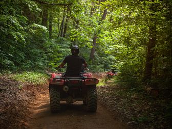
If you're researching Rio Grande del Norte ATV trails, you're probably looking for something different from forested mountain routes or muddy eastern trail systems. This corner of northern New Mexico delivers a stark, wide-open riding experience defined by high desert mesa country, rugged volcanic rock, and long views into the Rio Grande Gorge. Riders come here for the feeling of space as much as the trails themselves: expansive horizons, winding two-track roads, old ranch routes, and access corridors that trace the rim of one of the Southwest's most dramatic canyon landscapes.
At BestATVTrails, we researched this area as a destination for riders who enjoy remote terrain, changing weather, and a more self-supported style of off-roading. The monument and surrounding public lands near Taos, Questa, and Cerro offer legal motorized routes on designated roads and trails rather than a compact OHV park layout, so planning matters. Expect sun exposure, wind, sharp rock, and long stretches without services. For riders who want scenic mesa travel, volcanic terrain, and a true northern New Mexico backcountry feel, this is one of the most memorable places to ride.
Trail Overview

Rio Grande del Norte National Monument is not a single closed-loop ATV park, but a large network of designated roads and motorized routes spread across Bureau of Land Management lands north and west of Taos. Exact rideable mileage varies by route combinations and seasonal closures, but riders can piece together dozens of miles of legal motorized travel, especially around the Wild Rivers area, the Taos Plateau volcanic field, and connecting county and BLM roads near Questa, Cerro, and the western monument boundary.
Key Stats
- Trail system type: Dispersed network of designated BLM roads and motorized routes
- Estimated rideable mileage: Roughly 50+ miles of commonly used route combinations, with additional connector roads depending on current access rules
- Difficulty range: Green to Black
- Elevation: Generally about 6,500 to 8,000 feet depending on route
- Permit requirement: No general day-use ATV trail permit for most BLM routes, but vehicles must be street-legal where required or properly registered as OHVs where allowed
- OHV sticker: New Mexico OHV registration or a valid out-of-state permit is typically required for off-highway use; always verify current reciprocity rules through New Mexico Department of Game and Fish OHV Program
- Best season: Late spring through early fall; shoulder seasons can be excellent if roads are dry
- Nearest towns: Taos, Questa, Cerro, and Tres Piedras depending on entry point
Common ride planning starts near Wild Rivers Recreation Area, Cerro area access roads, or broader Taos Plateau route networks on BLM land. Because motorized access in a national monument is limited to designated routes, riders should always use the latest BLM travel map for the monument and surrounding field office lands.
Trail Conditions & Terrain
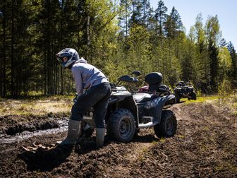
This is classic high desert mesa riding with a volcanic edge. Much of the terrain consists of hard-packed dirt, sandy stretches, loose gravel, and embedded rock. In many places, the surface is covered with angular basalt fragments from the Taos Plateau volcanic field. That means tire puncture risk is real, and underbody protection matters more here than on smoother ranch roads.
The riding character changes depending on where you enter the system. On mesa-top roads, expect relatively fast two-track and double-track sections with broad visibility, low vegetation, and occasional washboarding. These stretches can feel easy at first, but they often hide square-edged rock, rain ruts, and sudden erosion cuts. Near canyon rims and gorge access points, the routes become rougher and more technical, with tighter turns, steeper grades, shelfy sections, and rocky descents toward overlooks or river-adjacent access corridors.
You should not expect lush trail cover or frequent water crossings. This is a dry landscape. Creek crossings are generally minimal to nonexistent on the main mesa routes, but arroyos and drainage cuts can become a major factor after storms. Even a route that looks straightforward on the map can develop loose washouts, off-camber entries, or deep sand pockets where runoff has reworked the road.
Volcanic rock is the defining challenge. Basalt ledges, loose rock gardens, and jagged embedded stones can punish tires and suspension. Some roads are graded and relatively mellow, while others feel primitive and remote, with uneven surfaces, exposed bedrock, and stretches where line choice matters. In the more remote sections, you may also encounter cattle guards, gates, fence lines, and mixed-use traffic including ranch vehicles, adventure motorcycles, and high-clearance 4x4s.
Weather adds another layer. This area is known for high UV exposure, strong wind, and rapid temperature swings. A sunny morning can turn into a windy afternoon that fills the air with dust and reduces comfort fast. Summer monsoon storms can make roads slick in clay-heavy spots and can cut ruts into otherwise easy routes. In shoulder seasons, nights and mornings can be cold due to elevation, even when afternoons warm up quickly.
Difficulty & Who It's For
Because Rio Grande del Norte riding is route-dependent, we recommend thinking in zones rather than assigning one rating to the entire monument.
Green: Easy
Best for: Beginners with basic machine control, families on utility ATVs, and scenic riders who want broad roads and overlooks.
The easiest riding is on maintained BLM and county-style access roads across the mesa. These sections are usually wide, gently rolling, and easy to navigate in dry conditions. Hazards are mostly washboard, loose gravel, and occasional erosion. If you stay on major designated roads and avoid rough spur routes, many riders will find this a comfortable introduction to high-desert ATV travel.
Blue: Moderate
Best for: Riders with some off-road experience who are comfortable with loose rock, changing surfaces, and mild route-finding.
This is the most common difficulty level in the area. Blue routes may include rough two-track, embedded volcanic rock, deeper sand pockets, moderate grades, and drainage crossings that require a little momentum and line choice. Most intermediate riders on a capable ATV or side-by-side will do well here, especially in dry weather.
Black: Difficult
Best for: Experienced riders in well-prepared machines.
Black-rated sections usually involve sharper basalt rock, steeper descents or climbs near canyon terrain, more severe washouts, or remote roads where self-recovery is part of the equation. These routes are less about extreme mud or boulder crawling and more about sustained exposure to rough, technical volcanic terrain with limited support nearby.
Double-Black: Not typical, but possible in conditions
Best for: Highly experienced riders only, and usually only when conditions deteriorate.
The monument is not generally known for purpose-built extreme ATV trails, but a moderate route can become effectively double-black after monsoon damage, deep washouts, or if you push into primitive connectors without current route intel. Exposure, remoteness, and mechanical consequences elevate the seriousness level quickly.
Permits & Access
Motorized use in Rio Grande del Norte National Monument is controlled through designated route access on BLM lands. There is typically no blanket trail permit fee like you would find at a private park, but legal access depends on where you ride and what type of machine you bring.
What to know before you go
- Use only designated motorized routes. Cross-country travel is not allowed.
- Check the latest BLM Taos Field Office or Rio Grande del Norte National Monument travel maps before riding. Route status can change due to resource protection, seasonal conditions, or maintenance.
- OHV registration matters. New Mexico requires OHVs to be registered unless exempt, and out-of-state riders should verify whether their home-state registration is recognized under current reciprocity rules.
- Street-legal requirements may apply on certain connecting roads. Some routes involve county or public roads where a plated vehicle may be necessary.
- Spark arrestors and sound compliance are good practice and may be required depending on machine type and route classification.
Parking and staging
Parking depends on your chosen entry point. Riders commonly look at staging near:
- Wild Rivers Recreation Area vicinity for scenic access and nearby route options
- Cerro and Questa area public access roads for broader monument-edge riding
- BLM pullouts and dispersed staging spots where specifically allowed
Large developed OHV staging lots are not the defining feature here, so always confirm that your intended parking spot allows trailers and day-use vehicle staging.
Fees and reservations
- General riding reservations: Usually not required for day riding on designated BLM routes
- Monument entry fee: Most route access areas do not require a separate monument riding permit, though developed recreation areas may have day-use or camping fees
- Camping reservations: Only needed if you plan to stay in developed campgrounds; dispersed camping rules vary by area
Because rules can shift, we recommend checking both the BLM New Mexico site and the New Mexico OHV Program before your trip.
Tips for Riding This System
- Download maps before you arrive. Cell service can be weak or nonexistent on the mesa. Bring a dedicated GPS or offline mapping app and cross-check with BLM route maps.
- Start with more fuel and water than you think you need. Distances feel longer here because services are sparse, and wind plus elevation increase fatigue and dehydration.
- Lower speed on volcanic rock. Fast-looking roads can hide square edges and sharp basalt that damage tires, wheels, and suspension.
- Watch the weather, especially monsoon forecasts. A dry route can become rutted or slick after a storm, and arroyos can change quickly.
- Protect yourself from UV exposure. Use tinted eye protection, sunscreen, a neck gaiter, and long sleeves or armored layers. This landscape offers very little shade.
- Respect mixed use and ranch access. Slow down near gates, cattle, hikers, anglers, and other vehicles. Leave gates as you find them unless posted otherwise.
- Don't assume every visible track is legal. The mesa is full of old roads and two-tracks, but only designated motorized routes are open to ATV travel.
FAQ
Are ATVs allowed everywhere inside Rio Grande del Norte National Monument?
No. ATVs are only allowed on designated motorized routes and roads where that vehicle type is permitted. Cross-country travel is not allowed, and some nearby roads may require street-legal registration.
Do I need a permit to ride Rio Grande del Norte ATV trails?
Usually there is no separate day-use ATV trail permit for most BLM routes, but you may need valid New Mexico OHV registration or qualifying out-of-state registration, depending on your machine and the roads you use.
What is the best time of year to ride here?
Late spring through early fall is generally best. We especially like May, June, September, and early October for milder temperatures. Summer can be excellent but brings stronger sun exposure and monsoon storm risk.
Is this a good place for beginners?
Yes, in parts. Beginners can enjoy easier mesa roads and scenic designated routes in dry conditions, but the area is still remote. We recommend that newer riders stay on major roads, ride with a partner, and avoid rough canyon-adjacent or heavily eroded sections.
Rio Grande del Norte is less about tight trail density and more about the quality of the landscape: big skies, lava-shaped terrain, and canyon country that feels uniquely New Mexican. For riders who value scenery, solitude, and route-based exploration, this system stands out. With the right maps, the right machine setup, and gear suited for wind, UV, and sharp rock, it can be an outstanding destination for a full day or weekend of high-desert riding.
At BestATVTrails, we recommend treating this area with extra respect. It rewards preparation. Plan your route, verify legal access, carry navigation and hydration, and expect conditions to feel more serious than the mileage alone suggests.
Get our best guides in your inbox
Top Picks & Comparison
| # | Product | Price | Rating | ||
|---|---|---|---|---|---|
| #1 |  |
Rio Grande National Forest, Colorado (Classic Reprint) |
$26.06 | — | Check Price on Amazon → |
| #2 |  |
Rio Grande del Norte: An Intimate Portrait |
$49.99 | (10) | Check Price on Amazon → |
| #3 |  |
Classic Day Hikes of the Rio Grande del Norte National Monument |
— | — | Check Price on Amazon → |