Richfield ATV Trails Guide

Alana Azzouz is a Senior Editor at Searchshop Media Network with over a decade of experience in consumer content quality and editorial standards. She has reviewed thousands of product guides, buying articles, and comp…
Why trust us
BestATVTrails trail guides are researched by riders with decades of powersports experience. Our lead researcher spent 30+ years in powersports retail and has ridden trails across a dozen US states. Every gear recommendation is sourced from real product research matched to specific terrain — not paid placements or generic affiliate lists.

Richfield ATV Trails Guide
Gear for This Trail

Because Richfield combines cooler alpine mornings, dusty afternoons, loose rock, and remote forest mileage, we recommend gear that balances protection, navigation, and comfort over a full day ride.
| Gear Type | Brand | Product | Why it suits Richfield-area trails | Approx. Price |
|---|---|---|---|---|
| Helmet | Bell | Qualifier Full-Face Helmet | A full-face helmet makes sense for dusty forest roads, fast gravel connectors, and cooler high-elevation starts. The Bell Qualifier is widely available, reasonably priced, and well suited to mixed-speed mountain riding. | $120-$180 |
| Protective gear | Alpinestars | Bionic Action Chest Protector | Richfield routes can include embedded rock, branches, and surprise washouts. This chest protector adds upper-body coverage without being overbuilt for non-motocross trail days. | $130-$180 |
| Gloves | Fox Racing | Dirtpaw Gloves | These work well for long days with frequent throttle input, dust, and changing temperatures. They offer solid grip on hardpack and rough two-track without costing premium money. | $25-$40 |
| Terrain-specific item | Garmin | Tread Powersport Navigator | This is one of the best matches for the Paiute/Fishlake riding style because route-finding matters in a big connected system with many junctions and forest-road spurs. A dedicated powersports GPS is more reliable than depending only on cell service. | $500-$700 |
| Recovery item | Rhino USA | Recovery Tow Strap | Muddy meadow edges, shallow drainages, and loose climbs can stop even capable machines. A quality tow strap is a smart lightweight backup when riding the more remote Richfield loops. | $30-$45 |
| Comfort/utility item | Kolpin | Fuel Pack Junior 1.5 Gallon | Some Richfield loops are longer than they first appear, especially when adding scenic detours. An auxiliary fuel pack helps when services are far below in town and high-country mileage adds up. | $70-$100 |
If your ATV has limited underside protection, a model-specific skid plate upgrade can also be a smart add-on for rocky connectors and water-bar impacts in the Fishlake National Forest zone.
Introduction
Richfield Utah ATV trails give riders a strong mix of mountain forest roads, open meadows, aspen-lined routes, and cooler summer riding than many lower-elevation desert systems in the state. Based in central Utah, Richfield is a popular launch point for exploring the Fishlake National Forest side of the Paiute ATV Trail network, along with nearby connectors, scenic overlooks, and long day loops that can be tailored to beginner, intermediate, or advanced riders.
Riders visit this area because it combines convenience with real range. From town, you can quickly reach trailheads that climb into higher country, where temperatures stay more comfortable in midsummer and the scenery shifts from sage foothills to pine, fir, and broad alpine meadows. The area also works well for multi-day trips, since Richfield has fuel, food, lodging, repair services, and direct access to major OHV routes. We recommend it for riders who want scenic mountain mileage more than technical rock crawling, but there are still rougher sections, steeper grades, and remote connectors that keep the system interesting for experienced crews.
Trail Overview

Richfield is best understood as a gateway to several connected Paiute ATV Trail segments and nearby Forest Service roads rather than one single loop. Common riding zones from Richfield include access toward Marysvale, Monroe Mountain, Koosharem, Manning Meadows, and the broader Fishlake National Forest network.
Key stats
- Trail system: Paiute ATV Trail access from Richfield and nearby Fishlake National Forest routes
- Approximate rideable mileage nearby: 200+ miles of practical day-ride options from the Richfield area, with access to a much larger regional network
- Difficulty range: Green to Black, depending on route choice
- Typical elevation: roughly 5,300 feet in Richfield up to 9,000-10,000+ feet on higher mountain segments
- Permit/OHV requirements: Utah OHV registration or non-resident OHV permit required for qualifying machines on public routes where OHV use is allowed
- Best season: Late June through early October for high-country riding; lower routes may open earlier depending on snow and mud
- Nearest town: Richfield, Utah
- Closest major services: Fuel, groceries, lodging, restaurants, and repair support in Richfield
Because snowpack can linger, higher Forest routes often do not fully open until summer. We recommend checking with the Fishlake National Forest and local Paiute Trail resources before planning a high-elevation loop.
Trail Conditions & Terrain
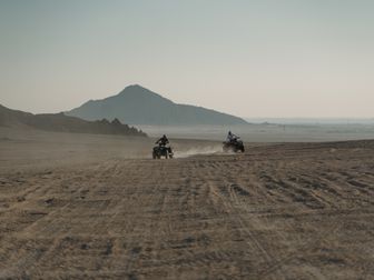
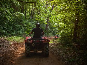
The Richfield riding area is defined by forest and meadow terrain with long stretches of graded dirt, native soil two-track, embedded rock, and occasional loose climbs. Compared with Utah’s red-rock desert systems, this zone usually feels cooler, greener, and more varied in traction.
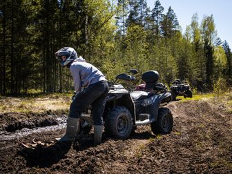
Near town, riders often begin on wider access roads with a mix of hardpack and gravel. As routes climb, the character changes into mountain two-track and forest roads bordered by aspen, spruce, fir, and open grazing meadows. In dry weather, much of the surface is fast and friendly, especially on maintained connector roads. After storms, however, the same roads can develop slick mud, shallow ruts, and washboard sections.
Expect these common conditions across Richfield-area routes:
- Hardpack dirt and decomposed gravel: Common on major connectors and maintained forest roads
- Loose rock and embedded stone: More frequent on steeper climbs and less-maintained side routes
- Meadow-edge mud: Seasonal wet spots are common near springs, shaded drainages, and cattle areas
- Water bars and drainage cuts: Usually manageable but can surprise newer riders at speed
- Steep grades: Not extreme by Utah standards, but enough to require low gear and good line choice on select spurs
- Dust in late summer: Especially on busy weekends and lower, drier roads
- Potential creek or runoff crossings: Usually shallow, but depth varies after storms and snowmelt
Routes toward Manning Meadows and the higher Fishlake side often deliver the classic alpine experience many riders come for: cooler air, broad views, and rolling meadows broken up by timber. Some sections are smooth enough for casual family groups, while others become rougher with erosion, rock shelves, or off-camber corners. The terrain is rarely extreme enduro-style riding, but it can become demanding when weather changes quickly.
Wildlife, cattle, and mixed traffic are also part of the experience. It is common to share roads with UTVs, Jeeps, dual-sport riders, and local ranch traffic on legal routes. That means blind corners, dust plumes, and changing trail width matter more here than in isolated single-use systems.
Difficulty & Who It's For
We rate the broader Richfield trail system as Green to Black, depending on the exact loop.
Green
Best for: beginners, families, casual riders, newer ATV owners
Many main forest roads and well-traveled Paiute connectors near Richfield fall into the Green category when dry. These routes usually offer wider tread, moderate grades, and fewer technical obstacles. They are a good fit for riders who want scenery, wildlife viewing, and a relaxed pace without constant technical input.
Blue
Best for: riders with some mountain trail experience
A large share of the Richfield Utah ATV trails experience sits in the Blue range. Expect narrower two-track, loose corners, moderate climbs, embedded rock, and occasional mud holes or drainage crossings. Riders should be comfortable standing on the pegs, choosing lines, and managing traction changes through shade, meadow, and forest transitions.
Black
Best for: experienced riders on longer or rougher routes
Black-rated sections are usually not about extreme obstacles; they are more often about exposure, remoteness, roughness, and sustained elevation change. Steeper climbs, eroded descents, rockier connectors, and weather-damaged roads can push a route into this category. We recommend Black segments for riders who carry navigation, recovery gear, and enough fuel range for detours.
Double-Black
Best for: not typical in the main Richfield-access network
We would not classify the standard Richfield-access Paiute and Fishlake routes as true Double-Black terrain for ATVs. There may be isolated side routes or poor-condition segments that feel much harder after storms, but this region is generally better known for scenic mountain mileage than highly technical obstacle riding.
Permits & Access
Richfield is one of Utah’s more convenient OHV base towns, but riders still need to pay attention to state and federal access rules.
OHV registration and sticker requirements
In Utah, ATVs and other OHVs generally need to be properly registered.
- Utah residents: need current Utah OHV registration where applicable
- Non-residents: need a Utah non-resident OHV permit unless their machine qualifies under a reciprocity exception that does not apply to many trail riders; most visiting riders should plan on obtaining the Utah permit
- Street-legal machines: if your ATV/UTV is fully street legal under Utah rules, some access situations differ, but trail legality still depends on route designation
Permit pricing can change, so we recommend checking the Utah State Parks OHV program for current costs before your trip.
Forest access and route legality
Many Richfield-area rides enter the Fishlake National Forest, where travel is limited to roads and trails open to the vehicle type you are using. Stay on designated routes and review the current Motor Vehicle Use Map (MVUM) or local trail map.
Parking and staging
Common staging depends on the route you choose. Riders often stage from:
- Designated Paiute Trail access points near Richfield
- Forest access roads outside town
- Lodging or OHV-friendly properties where legal trail access is provided
Parking availability is usually better than at heavily urbanized trailheads, but holiday weekends can still get busy. Arrive early if you want to avoid crowded staging areas.
Reservation requirements
For day riding, trail reservations are generally not required. If you plan to camp in developed campgrounds in or near Fishlake National Forest, some campgrounds may use reservation systems or first-come, first-served rules depending on the site and season.
Costs beyond permits
- OHV permit or registration fees
- Fuel in Richfield before climbing into the mountains
- Possible campground fees if staying overnight in developed sites
Tips for Riding This System
- Start with a realistic mileage plan. Richfield-area loops can look easy on a map, but mountain junctions, scenic stops, and rougher connectors often make the day longer than expected.
- Carry navigation beyond your phone. Cell coverage can be inconsistent once you are deeper into Fishlake National Forest, so a GPS or offline map is worth bringing.
- Dress for temperature swings. It may be warm in Richfield and cool at elevation. We recommend layering, especially for morning departures and afternoon thunderstorms.
- Fuel up before leaving town. Richfield has solid services, but once you are on the mountain, fuel options are limited and detours can add significant miles.
- Watch for afternoon weather. Summer storms can turn fast hardpack into slick mud and reduce visibility on exposed roads. If clouds build early, shorten the loop.
- Expect mixed traffic. These routes are popular with UTVs, Jeeps, and other recreation users. Slow down for blind corners and keep right on wider roads.
- Respect wet meadows and soft shoulders. Alpine terrain is beautiful but fragile. Staying on the established route helps avoid getting stuck and reduces trail damage.
FAQ
Are Richfield ATV trails good for beginners?
Yes, parts of the system are beginner-friendly, especially wider forest roads and easier Paiute connectors in dry conditions. We recommend that newer riders stay on well-traveled Green routes and avoid long remote loops until they are comfortable with mountain terrain.
Do I need a permit to ride near Richfield, Utah?
In most cases, yes. Your ATV or OHV generally needs valid Utah registration or a Utah non-resident OHV permit, depending on where you are from and what you are riding. Always confirm current rules with Utah State Parks before the trip.
What is the best time of year to ride Richfield Utah ATV trails?
The best season is usually late June through early October for the higher alpine routes. Lower roads may open earlier, but snow, mud, and downed trees can delay access to the best mountain sections.
Can we ride directly from Richfield to the Paiute Trail?
In many cases, yes, Richfield functions as a practical access town for the Paiute ATV Trail network and nearby connectors. Exact ride-from-town legality depends on your machine setup and the specific route, so verify local access and street-legal requirements before heading out.
Get our best guides in your inbox
Final Thoughts
Richfield stands out because it gives riders easy access to cooler alpine terrain, meadow scenery, and major Fishlake National Forest connections without sacrificing town services. For many Utah riders, that combination is exactly the sweet spot: long scenic mileage, a broad difficulty range, and enough route variety for either a casual day ride or a full multi-day ATV trip.
5.99★★★★★ (82)Check Price on Amazon →If your goal is scenic mountain riding rather than extreme technical crawling, Richfield Utah ATV trails deserve a spot high on your list. Plan around elevation, changing weather, and fuel range, bring navigation you trust, and you can build one of the better central Utah OHV trips available from a single base town.
Top Picks & Comparison
| # | Product | Price | Rating | ||
|---|---|---|---|---|---|
| #1 | |
ATV Trails Guide Arizona Phoenix Region |
$15.99 | (82) | Check Price on Amazon → |
| #2 |  |
ATV Trails Guide Moab, UT |
$24.95 | (127) | Check Price on Amazon → |
| #3 |  |
Guide to Colorado Backroads & 4-Wheel-Drive Trails (FunTreks Guidebooks) |
$29.31 | (1,867) | Check Price on Amazon → |
| #4 |  |
ATV Trails Guide Colorado Taylor Park, Crested Butte |
— | (52) | Check Price on Amazon → |